From top to bottom, my day in photos

Because it’s late, I’ll just do a photo entry. :) County Clare today.

20130515-231728.jpg

Ferry trip across the Shannon

20130515-232130.jpg

Cliffs of Moher – some notable movies used them as a backdrop (Harry Potter and the Half-Blood Prince – I know where the locket horcrux is…). Also? Friggin’ amazing in real life.

20130515-232406.jpg

Doolin Cave – 200 feet below ground and a stalactite that looks like fabric hanging from the ceiling, that was about this large when the pyramids were being built. I wore a hard hat and bonked my head on the roof of the tunnel. Saw a fossilized worm and fossilized coral where the actual prehistoric sea bed was. It is very dark underground, 12C and 95% humidity.

20130515-232736.jpg

Galway – Quay Street at about 8:45 pm. I went to The Malt House for dinner and had my pint of Guinness at The King’s Head while listening to a trad music concert. Not a session, per se, but the bodhran player was impressive. The King’s Head is so named because that land was given as payment to the Galway man who beheaded Charles I.

Hiking day

I had two plans today. The first was to hike in the national park near Killarney (Cill Airne) (Cill is “church” in Gaelic). The second was to see Moll’s Gap, the Gap of Dunloe (another mountain pass) and a little bit of the Ring of Kerry.

Well… I just hiked the park. I think I walked more than 20 km today.

20130514-213245.jpg

I pulled into the first parking lot I could find marked “Killarney National Park” and got my gear together. I’d made use of utensils at my B&B this morning and had premade my hummus wraps, so that made carrying them way less messy. There were horse-and-trap rides (jaunting cars) waiting to take fares, but I was bound and determined to do this under my own power. So I ran across the highway N71 (you didn’t hear that, Mom) and started strolling in to Killarney National Park. No admission, just wandered in. No parking fee either.

20130514-214158.jpg

Instead of taking the slightly paved pathway, I took a smaller, more “organic” footpath by Lough Leane. I realized later that it was better to stick to footpaths because the jaunting cars drive on the paved paths and you have to step off to give them right of way.

And that’s when I was engulfed by the humid greenery of the park. Leaves are just unfurled and are still growing, but yet so much is so green. I walked along the lake, where a lot of the trees still seemed pretty young, and my footpath intersected with the paved path and a signpost pointing to Muckross Abbey. I had the general idea I wanted to see the Torc Waterfall while I was here, so I was trying to aim in that sort of direction. I knew that the Muckross Abbey and Muckross Estate were before that, so I thought I’d stop by on my travels. I wasn’t in a huge hurry.

Muckross Abbey was a ruined Franciscan friary with two gigantic and impressive yew trees. One was right out front, and the other was in a courtyard that, when I was pacing around the square sunken hallway and looking over the low wall into the raised courtyard and tree, I couldn’t help but think I’d seen something like this before. Of course, turn it all into pixels and there’s a courtyard like this in Stormwind (geek humour). I hopped the wall to go touch the giant yew. Eventually it will outgrow that large opening and may start pushing at the walls. Or the park may prune it so it doesn’t. I’m not sure how that sort of historical site management works.

I climbed some more spiral stone staircases and walked through the rooms that the friars would have used daily. It’s a remarkably intact site, so it must be relatively new. I wandered around the graveyard and there were some new burials there (2012) so it is clearly still an active site as well.

Then a followed a couple of girls up another footpath and found myself on a paved path (this time with cars too). I just kept walking “against traffic” and hopping off onto the grass. I passed by the Traditional Farms, which show how farming was done in Ireland in the 1930s. Which doesn’t seem that long ago, but that’s 80 years – farming technology has changed.

I eventually turned a corner and started walking towards a huge manor house like something out of Jane Eyre or Pride and Prejudice. It was Muckross House, a 19th century mansion. I didn’t pay the admission fee to go and see the inside of it, but it looked grand. There was scaffolding up on the one corner of it so I wasn’t able to get a good clean photo of the outside.

I was now 2 km from the Torc Waterfall, and so I kept on walking. I passed onto a walking path to get out if the way of the jaunting cars again and was enclosed in the forest once more. Very few people were out, so it was like I had the forest to myself. Divine. The humid understory scent of trees, leaves, the tang of resinous pine, the gurgle of little rills and streams, the complex songs of the little birds flitting through the underbrush. It occurred to me that the pattern the ivy makes as it weaves itself over the trees could have inspired Celtic knotwork designs.

In order to get up to Torc Waterfall, I ended up on a rated walking path. The moderate and easy overlapped a bit, with the moderate taking slightly steeper hills. I kept to the moderate path, also because the hard path had loads of warnings on it and was about 2 hours longer than the moderate one. But I followed the running stream all the way up to Torc Waterfall. Majestic.

20130514-221811.jpg

I took many shots, as the clouds covered and uncovered the sun, letting me play with different lighting effects with the running water. I know a lot of photographers like the running stream, longer exposure blending for waterfalls, but I like seeing the shape the falling water is taking that very instant so I like the quick exposures. After that, I turned around and there was a stone stairway up.

For those who know, that first really special graded climb on Wolf Trail in Gatineau Park, think that but longer. The stairs helped for footing, but I was still climbing the side of Torc Mountain. And climbing. And climbing. And puffing and sweating.

20130514-222413.jpg

I believe I was on the bottom right hand stretch of the yellow dotted path, right before the turn. This was the “go up the side of the mountain so you can walk across it to get back down to the bottom” part and honestly, it was the toughest part of the whole walk. But I did it, huffing like I was running a race.

It started to cloud over as I was coming back down the mountain side (Torc Mtn is 535m tall). I got a few more shots before I put my camera in my backpack, just in case.

20130514-222941.jpg

I had just crossed another portion of highway and was passing by a little farm, where a workhorse was busily munching the close cropped grass of its paddock when it curiously perked its ears and went to the fence to look further back in the yard. And there was a little old farmer “sneaking up” on his German Shepherd, who was lying on the ground with something in its mouth, watching him. His back was arched, his hands were up in an almost cartoon villain pose and he was taking exaggerated slow steps towards the dog. He circled around behind it and the dog rolled over on its back, still holding whatever it was in its mouth and the farmer leaned down to give the dog a belly rub.

I laughed and walked a few more steps and looked left. And saw two deer frozen like statues watching me, right out in the open. They were so still, I thought for a moment they were statues just put up so that tourists would know what it would be to see these elusive red deer. Until one of them moved and I said out loud, “Oh! They’re real!” I’d already been taking pictures of them but then I tried to get a few more before they fully disappeared.

It was when I was heading back to Muckross House that the rain hit. My hood was up and I was thankful for my real rain jacket. I quickly stopped by the cafe there to see if I could get a take away tea or something but I didn’t see any take away cups. I popped into the gift shop and was able to find three of the books published by the Blaskett Island folks I learned about yesterday. Since I finished my novel a couple of days ago, I thought I’d pick up a couple to read while I’m here. The lady at the cash told me that “her generation” had Peig as compulsory reading in Gaelic during their high school so they kind of resented it. I’m sure I’d feel the same way about some of the Canadian greats we had to read. I also picked up The Islandman, both in English for now.

Then I started trudging back to my car beyond Muckross Abbey. I passed by a sign saying 5 km to Killarney but I hadn’t parked that far away. It just felt like it at that point. But then I looked across the field and stopped dead on the paved pathway. There lay six red deer, just having an afternoon snooze. I wrestled my camera back out of my backpack and took some photos, and was able to do more, slightly closer, after I’d passed a copse of trees. Amazing way to end my hike.

I took out my last wrap and ate it while passing through the forest by way of the same walking path as before. And I found a horseshoe on the path back to Muckross Abbey. Someone had thrown a shoe. I picked it up because I thought if wouldn’t do either the horses or the traps any favours if they ran over it, and carried if for a while trying to think of what to do with it. I didn’t need to bring it back with me. No one needs a used horseshoe. And it was heavy. I didn’t think it went with the B&B’s decor, so I propped it up along the fence, open side up to keep the luck in, and left it for someone else.

I was raining for at least the last hundred metres leading up to the highway where I’d have to run across to get my car. No wonder the path was deserted – only my car and one other was left in the parking lot. And then the sky opened up just as I was diving into my car. It even was a heavy rain/hail mix again as I was coming in to Tralee. I had to slow right down to be able to see and at one point I pulled over. And then it was done and the sun was shining.

Tomorrow I’ll be making my way to Galway, via County Clare and the Cliffs of Moher. :)

The Amazing Dingle Peninsula

Today, I tackled the Dingle Peninsula, which is super close to where I’m staying in Tralee. Basically less than fifteen minutes driving and I’m on my way around the peninsula.

I veered north off of the N86 at Camp (An Cam) and took Regional Road 560 up to Conor’s Pass. First, I took a tiny (literally) side road down to see the amazing breakers rolling in to Brandon Bay (Ba Bhreandain) along the Fermoyle Strand at Stradbally (An Sraidbhaile). This area is pretty Gaelic so at one point, there wasn’t any English on the road signs and I was navigating via Gaelic alone. :)

Then I continued along Conor Pass. Waves of rain were coming through off the coast, and it seemed to get colder as I drove up into the mountains. I was basically driving on the side of Knockmoylemore and Knockmulanane, across from Ballysitteragh Mountain, Brandon Peak and Mount Brandon. As Seamus, my B&B owner suggested, I knew I was close to the actual pass when I looked down to see the valley on my right dropping about 400 feet below me. As I was driving up to that point, I was contending with crazy rain, hail and random sheep and lambs on the side of the road.

I stopped at a handy parking pad on the side of the road right where a lovely little waterfall was running down the side of the gorgeous mountain (just the beginning of the stunning gorgeousity of Dingle) and thought that the Irish tourism office had provided an excellent viewing point for those camera happy folks. Oh no, that wasn’t it at all. That was the waiting/staging area for the run up the pass that is only really wide enough for one car. It’s so you can sit there and wait for traffic to come down the mountain. I took some pictures anyway, then hopped back in the car, backed around all the other tourists thinking this was a strategically placed “outlook” and made my run.

Now the rule that Pili, my other B&B owner told me that I really didn’t understand this morning over my soggy cornflakes and tea, is that the cars going up give way to the cars going down. I was going up. I did, in fact, meet a car halfway through my traversing. I did pull over – against the mountain *ding!* {lightbulb} – on a little patch of “pull over” gravel (I was lucky that way) and the guy waved and squeezed past and I made it to the top. Where there is another parking pad – this one a little more believable as an outlook vista view as well as staging area.

So, lightbulb discussion : Why, in a country where you drive on the left hand side is the road, when you put a road on the right flank of a mountain, does the ascending lane yield right of way? Because the descending lane can’t – they’ll fall off a cliff. So now you know who always has the right of way on narrow mountain roads – the outside guy facing the precipice.

So that was exciting.

Then I threaded my way through Dingle (An Daingean), and started my tour around Slea Head (Ceann Sleibhe). And despite my earlier plan to drive the opposite way, I did end up driving around clockwise so I was always on the cliff side. *sigh*

One of my first stops was a “Prehistoric Celtic Museum” in a little house on the side of the road. I thought Why not? I wanted to have my banana and a sip of water (I was trying to wait to have a picnic lunch at Clougher Head). I went in and paid my admission, and toured through some lovely artifacts – axe heads, spears and daggers of flint, the beginning of copper, then bronze tools and weapons, a mammoth skull reassembled from pieces dragged up from the bottom of the North Sea in a fishing net, another giant Irish deer skull with broken antlers (found in an Irish bog) (Megaloceros). And tons of jewelry and pins, hair adornments and chariot pins, funerary items and whatnot. I took pictures of the later Celtic stuff, but the spirals and trefoil (and quadrefoil) are accurate in that way. Too neat.

The next place I stopped was another handy parking pad at the (cliff) side of the road with a fabulous vista view, but also access to beehive huts for 2 euro. The information indicated that they had been built in 2000 BC, and were considered to be Fahan (maybe an era). I didn’t go inside (people were clearly smaller back then…) but it was pretty awesome. I also could see the “emergency bunker” type souterrain for use by the family that would have lived in the ring fort if something really dangerous happened (raiders, Vikings… The usual).

20130513-224306.jpg

I continued on to Dunmore Head and parked the car to walk down to the beach.

20130513-224735.jpg

It was spectacular. The waves were roaring, so powerful. They sprayed foamy white off of the sharp rocks of the headland, and the ocean itself was such a blue-green. I walked along the sand, and then hiked along the cliff.

I have to say, one of the best pieces of photography advice I’ve ever received was, sure, take the photo you see. But then, turn around and see what’s behind you. So while I had a ton of surf shots, I turned around and looked *at* the cliffs towering above me, and saw their geology, their erosion, the plant life and the tiny cave at the bottom that, when I peered inside, revealed a large vein of white quartz-like rock again, intruding on the limestone/shale/sandstone formations. I think there was some flint or something as well (everything is heaved at very sharp angles so a lot of layers are showing). Fantastic.

At this point, I was coming level with the Blaskett Islands (Na Blascaodai) and they had an interpretive centre there, because they had to abandon their villages due to low population making the community unviable. I pulled in to the parking lot and had another quick bite (hummus, sun almost-dried tomatoes in oil and herbs, and white cheddar in a tortilla wrap) and then went in and paid my entry. The story of these islands is amazing – professors came to the island to learn Gaelic because it was one of the last remaining bastions of the Irish language. As a (small) society of storytellers, they produced many poets and writers, and inspired many as well. One of the exhibits was “learn to speak Gaelic” and I got seven right before my timer was up (not sure how long that was). It was fascinating to see how self-sufficient the people were and they even had a King. In 1953, after the population had dwindled to only 20 folks, and they were getting old and unable to keep the community going, they were evacuated from the island and relocated. A lot of the young people were emigrating to America, and in Springfield, Massachusetts you may hear some South Kerry Gaelic being spoken, because a number of islanders ended up there.

It was heartbreaking and breathtaking all at the same time – the loneliness of giving up a home and lifestyle that you’ve always known – where you expected to be able to live out your days surrounded by your grandchildren, and to be left behind. There were quotes from folks who were trying to take care of some of the sad old grandmothers, sitting alone in an empty house, not hearing from their children and grandchildren who had moved so far away. But also what they were able to accomplish – they wrote down what their lives were, how they lived, preserved a language from extirpation. I was wondering if someone would be permitted to restart a community over there, but then wondered who would go.

At Clogher Head (Ceann Sraithe), I stopped and hiked up the cliff to be at the most westerly point of Ireland. The closest to home I’ll get without a boat or a plane. A kiss was tossed against the wind there. And masses of pictures were taken, but then I had to race the next storm back to my car. I stopped at one point, risking wet, to inspect a suspect standing stone. I’m not sure if it was an actual standing stone or perhaps an arranged one, but it was lichen covered and weathered on all sides, so perhaps. :)
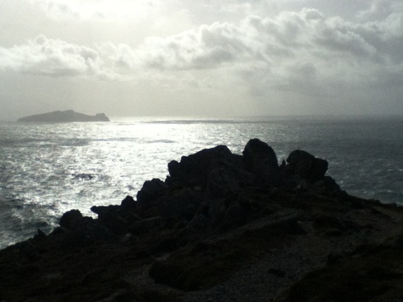
20130513-231925.jpg
Looking west

At this point, I had decided that I’d had enough exploring and it was time to go find myself dinner. It was almost 6:00 (though the sun doesn’t go down until after 9:00, I’ve noticed). But for some reason, I turned left instead of going straight, and I headed to the Gallarus Oratory. It was fantastic – not ruined, not even tipping or cracking, and dry as a bone inside. Whoever built that structure 1300 years ago really knew their stuff! And the fellow at the counter asked if I’d received a map of Dingle yet, to which I replied no, because I hadn’t. So he got out his little pamphlet and he directed me to stop at Kilmalkeldar Church (Cill Mhaolcheadair) ruins and suggested I take in the little film that they had running in their tiny “theatre”. So I did and it was really interesting – lots if information about the ring forts and beehive building technique, and about the church ruins he’d directed me to – it basically sold me on the idea of going right away.

It was pretty simple to find, and I am really grateful I’m here at the beginning of tourist season (and that it was ranging from a blustery 5-10C today – brrr!). It means I can slow down to read the road signs and make sure I’m turning at the right spots. I wandered in and there it was – an Ogham stone. Amazing. So weathered, about 5′ 4″ -ish, with a hole bored through the top (east-west) and the lines inscribed across the corners. The inscription reads “Anm Maile-Inbir maci Brocann” (The name of Mael Inbir, son of Brocan). There was also an ancient stone sundial there with engravings on it, and a Roman language stone, similar to the Ogham stone but inside the church ruins and possibly used to teach little ones how to read and write the Roman alphabet.

After that, I went back through Dingle to Camp and stopped at Ashe’s Pub for dinner. It was 8:00 and I was starving. I’d considered just having a third hummus wrap and making my way back to my B&B but I really couldn’t do it. So I wandered in, and was faced with the decision I was dreading. The only veggie option on the menu was garlic bread. I was the only customer in the place besides two lads watching football and throwing darts and the barkeeper (owner?) had already poured my half-pint of Guinness. So… I ordered the cod and chips. I knew if I had to waiver from my veggie diet, I’d rather have fish first. So I sat down and sipped my beer and waited. I didn’t really feel that terrible about the decision – I wasn’t causing offense or making a scene, I wasn’t being a diva and I was being practical. I’d pushed myself as far as I could today and this was a point I had to, and felt I could, concede.

I haven’t ordered and eaten meat in a long time, but the cod was good. It was flaky inside, not overly fishy, and the breading was crispy and not sodden in oil, and the chips were great. I finished my tiny (sad really, but again – practical) Guinness and the fellow asked if I wanted another. I said I shouldn’t since I had to make it “home” and went to pay. Another day where I regret emptying so much of my change – I’m sure my tip was insufficient. We chatted a bit and he knows of Seamus, and he gave me some hotel names for coffee or tea and scones for tomorrow around Killarney (Royal Hotel, Lake Hotel, I think). Very kind of him.

My stomach started feeling a bit nauseated on my way back to Tralee, but it’s settled down. It’s not like my steady diet of eggs hasn’t prepped it for additional animal protein.

But Dingle Peninsula has been an amazing experience and I’m really glad that I did the tour!

It’s not that long of a way to Tipperary…

So I set out from my lovely Duncannon B&B, trying to be methodical about getting to, basically, the other side of Ireland. Now Ireland is comparable in size to, say, New Brunswick in Canada, which is not insignificant, but you can at least get to the other side of it in less than a week. Which is infinitely more practical when one has chosen to drive. Or maybe it’s the other way around…

Anyway, the car ferry at Ballyhack was an exceedingly good call. It cut a whack of driving off, was interesting, and I got to be the “slightly awkward but really sweet girl muddling her way” to two local men chatting while leaning on the seawall this morning when I asked, “Um, hi there. How does the car ferry work? Where do I line up?” And they had a bit if fun, “How does it work? You drive on and they float you across.” And then they helped, pointing to where I should stop and wait for the ferry to come back.

So I sat there with the end of my car hanging out into traffic (which means I couldn’t find an extra six inches to pull over… I’m just too used to a 17 foot car), with the window down and listening to an Irish Gaelic radio show – just Irish Gaelic being spoken. I was recognizing words! I don’t know what they were saying, but I could hear some of the words that I sing when I’m doing the Sean Nos songs I learned. A pack of cyclists pulled up waiting too. Then the boat arrived and I was in the middle. Two cars pulled on ahead of me and then a motorcycle and another car behind. The cyclists were first. I paid for a one way trip, but it would have been a better deal if I’d been coming back (could have saved a couple euro – 7 euro one way, 12 return). We disembarked and the cyclists went first. Apparently Irish drivers have very little patience for cyclists because they all quickly passed, even on blind corners, which I thought was ill advised (hence why I wasn’t). Indeed, one car had to swerve back amongst the cyclists because another car came whipping around a corner, honking at the car that was in his lane (i.e. the right one). ;) I waited until we hit a longer clear stretch and then passed the pack. Apparently Sunday cycling is big around Waterford.

I didn’t spend any time in Waterford. It was a very cute town and I would have enjoyed myself, I’m sure. Maybe next time.

I made it to the Rock of Cashel with 7 minutes to spare before the tour started. What an amazing site. Granted Cormac’s Chapel smells like someone’s mouldy, damp basement but they’re fighting that, because the mould is destroying the newly uncovered 12th century original frescos. They were apparently painted over with lime during the Reformation because they were considered idolatrous. And the lime didn’t help them either.

The graveyard had some spectacular Celtic crosses and is still an active burial site, and has been since the 1100s! There was one grave site which was for a young lad, a pilot, who died in a crash during one of the World Wars. Another mausoleum had a ginormous Celtic cross… Until it got topped in a bad storm in maybe the 1990s or something. Now it looks like they have an obelisk or a chimney, from afar. They left the pieces that broke off beside the mausoleum though. Really neat.

The cathedral was amazing and sad all at once. Essentially, one archbishop said, “Alright, folks. Let’s take this party elsewhere.” And he called for the abandonment of the site, I think, in the 1700s or 1800s. The cathedral is nothing but the bones anymore – just the stonework – all the timber, plaster, everything rotted away. The stonework is amazing – one part of the archbishop’s “house” (*cough castle cough*) had broken apart in a bad storm and it lets us see the cross section of the building – so much rock! The walls are a metre thick! The ceiling between the first “floor” and the second looks like it shouldn’t even stay up, there’s so much stone overlaying stone. And a lot of the carvings are still holding up, despite years of weathering. But it is limestone so it’s vulnerable.

Lastly, we went into the choir’s “apartments” which have been completely restored. They even built a new wooden roof in the appropriate style and using the appropriate building methods – no wood screws or nails here, no glue – this is all doweling and wood joining. Super cool. I thought my friend R would appreciate that. :)

I had lunch at Rock House, which was delightful. Veggie quiche. I overheard the one really animated server guy enthusiastically serving some folks in German. That’s one thing about hitting the tourist sites – you’re hanging out with other tourists. Several Eastern Europeans, Germans and at least one American today (who was behind me while we waited for the tour to start and suddenly there was a flood of folks from upstairs so I was craning my neck around to see where the door was, made eye contact with him and smiled and said, “I’m just wondering where all the people are coming from…” And he drawled, “I’ve been wonderin’ that my whole life.”)

Then I set out for Cahir, which wasn’t that far of a drive, really. And I was able to slip in to the tour for Cahir Castle very quickly and only missed the explanation of the first outer courtyard and dry moat looking thing (obviously could have benefitted from that interpretation, clearly). He showed us the Norman influence in the design and how it was set up to always provide the defensive advantage, even to the way the stone spiral staircases turned (to give the advantage to the upper defender – right hand freer). Apparently the portcullis is one of three working ones in Ireland, and it was featured in several movies, including Braveheart. It also has made an appearance in The Tudors. And I got the tour guide’s beer tester question right. Apparently, back in the day, if you were the beer tester, you would come to the banquet hall and pour some beer on the table (very ceremoniously, I’m sure) and then sit on the puddle in a special pair of leather pants (…). After half an hour you would try to get up, and if your pants were sticking to the table, the beer wasn’t fit to drink. And the tour guide asked why. I said, “It’s the sugar.” If there’s still enough sugar left in the beer to make the pants stick, then fermentation hasn’t happened adequately and the beer isn’t good. This was all discussed in the restored (but abbreviated) banquet hall under the enormous skull of a giant Irish deer. Amazing.

Then I began my rainy drive across the rest of Ireland. I stopped in a parking lot of a Catholic church in Kerry to take some amazing landscape shots and a fellow heading in to the church stopped by for a chat. He’d been a tour guide for a time so he was able to give me some helpful hints. He also thinks I need to come back because I’m missing out on a number of really interesting things. ;) It was a good chat, and we shook hands at the end – he said blessings upon me, and we exchanged names. And I jumped back in my car and continued to Tralee.

Now I’m safely ensconced in my B&B and I just heard some rain beating on the window. I am almost done my celebratory cider and will soon close my eyes.

But one last thing, the view of the Rock of Cashel from the parking lot.

20130513-001128.jpg

Grey morning

Firstly, Happy Mother’s Day back home. I know the day has just barely turned (I am five hours ahead of you, after all). And my mother certainly won’t be up and reading this yet (hi Mom!). But I hope my friends and family have a good Mother’s Day, especially those who are new to it, this being one of their first Mother’s Days.

I’m sitting on the end of my bed with the covers over my legs, looking out to the wet and grey day outside. I just spoke with the owner, Eric, and he’ll be serving breakfast a little after 8:30 – another lovely Irish (vegetarian) fry up – two eggs, beans, mushrooms, potatoes, and a small tomato with toast, tea, juice and yogurt. The car ferry at Ballyhack will be running this morning, beginning at 9:00, he said.

I was a little unsure given church and whatnot. Today seems to be communion day as there was a family at the chipper last night talking to their youngest about what she’s wearing to the eldest’s communion (a communion dress with communion shoes that are shiny, apparently). They were funny, and the dad kept running back into the kitchen where a rather violent football match was going on. They weren’t *exactly* tackling each other but… They weren’t giving out yellow and red cards for hugging either.., also, my next B&B owners and I arranged my arrival for 8:00pm because they had a communion to celebrate today as well.

You don’t really realize how secular we are in Canada until stuff like this pops up. And it makes you wonder if your heathen little soul is intruding on someone’s spiritual day because it’s really just another day for you.

But I just saw a heron flying low and fast over the quiet grey breakers. The first one I’ve really seen that I could identify. The other was in Wales and I only saw it at a distance and from a weird angle.

Anyway, wish me luck – I’m heading to my next stop and it’s a bit of a drive. :)

Hook Head

20130511-222810.jpg

Sorry it’s a bit crooked – I was kneeling at the edge of the cliff and bracing myself against the wind *and* trying to time the shot so the water would be rushing over the rocks. ;)

I did the Ring of Hook today, including starting out at Duncannon Fort (where the Count of Monte Cristo was filmed, apparently). The lighthouse tour was interesting – we climbed 115 stairs to get to the “roof” and the familiar gale force type winds coming straight off the bare Atlantic. Good thing I didn’t spend time on my hair (though there were a couple of girls who maybe did…). After that, I went to get more sea air and took those coast pictures (way more on my actual camera). I used my macro filters on the tidal pools (cute little barnacle guys and tiny little blue mussels) and on the fossils in the stone. There are intrusions in the rock as well (straight, intersecting white lines – quartz or calcite? I didn’t scratch it to see). I stopped at this little ruin on my way out to take some more sea pictures, and then I stopped at the Hook church ruin – St. Dubhan’s Church (Dubhan means “hook”). So interesting.

I then took a little hop over to Slade Castle, a ruin next to an active fishing pier/port. I was basically able to wander around there a little but since people actually live there, it’s tough to tromp into their front yards to take photos of their castle ruin.

But, I tripped over another castle ruin more on its own – Fethard Castle. Apparently not terribly stable (huge sign absolving whoever from whatever accident may befall you – a sort of “we warned you!” sort of thing). It was quite picturesque and I was able to see some baby oak leaves on one of the trees in front. I also switched to my wide angle lens to be able to get a picture of the fabulous mature tree growing out front.

And then I was on my (slow) way to find Tintern Abbey. Another set of ruins, but these were set far back from the road (and I parked near the road, unnecessarily). I hiked in the driveway, which was lovely and pastoral. I got some stares from the Irish cows and Irish sheep (and lambs). I heard some Irish warblers and maybe even some rooks? And then came upon the abbey. Originally housing imported monks from Wales (from the *other* Tintern Abbey), they were apparently very enterprising and sent out their monk workforce over all the lands that belonged to the abbey to make stuff or gather food all week, only returning at the end of the work week. Some of these guys had to walk 35km to get to their tasks. I also walked through some of the forest and found my way to the walled garden, which was just being planted / sprouted / blooming, but I got a few sweet shots of the early bloomers, including a really dazzling blue poppy.

But I have to go on a bit about the forest surrounding Tintern Abbey. It is really gorgeous. The bluebells were filling the glades below huge old muscular trees, which had ivy twining up them. If it wasn’t bluebells, then it was swaths and swaths of wild garlic. I wondered why I was getting whiffs of it here and there and really wanting something yummy and garlicky for dinner. Apparently one of the things the monks would take advantage of. The forest also has ruins in it – I found a tower that might have been a mill of some sort. And stone walls running through it that are breaking down and hosting ivy, ferns and flowers on it. As well as moss and lichens.

So after so much fresh air and wandering, I came back to town and grabbed a quick bite at the local chipper (veggie burger and a bag of chips – that is fries). Now it’s time to sign off! More Ireland to see tomorrow!

Brigid day

I was up and at ’em, sort of, this morning. I’ll admit to hitting the snooze button once. Breakfast was at 8:00 and I thought it was earlier, but that’s okay because it meant I got to fight with that hotel’s wifi for half an hour before I went to have my “vegetarian Irish breakfast” which ended up being two fried eggs in a puddle of oil (canola? Light olive oil?) and half a plate of beans (assuming tomato based because I didn’t see any pork pieces – shush) and two pieces of dry white toast. Thankfully, when I stay there at the end of my time here in Ireland, I won’t make it to breakfast because I’ll need to be at the ferry before 8:00. There is a restaurant on board, I will eat there. The girls in the kitchen were very nice, and I felt badly for them because a lady came in and bullied them to get extra help wherever she works and took one of the girls from the breakfast service with a smile of “what are you going to do about it? You need this job”. Ick.

Also, apparently Cmdr Chris Hadfield posted today a picture from space of the storm with gale force winds that I was ferrying through yesterday afternoon. It’s quite impressive.

So I went and picked up my car at the Dublin Airport and did one of two things that scared me today. I turned the key in its ignition and pressed the gas. And my cabbie (who I think ripped me off) was right – it’s not brain surgery. And I have almost 20 years experience driving. Seriously. So I went on the M50 ring road around Dublin and took the exit to N7 to Kildare. (Note: the one guide book that I’m referencing characterized the N7/M7 as “harrowing” – I found it fine, though it’s a four lane highway like the 417 or 401 with a “speed limit” of 120 kph.) Sure, I cut someone off in a roundabout, but I waved my sheepish sorry and kept going. And then I was in Kildare. I drove around town, and found myself a safe little parking spot, emptied my change purse of meaningful change (which I would come to regret later) so I’d have two hours of parking. And then I walked. And saw familiar names on the buildings, like Michael Joyce, an accountant, and J.J. Mahon & Sons. Folks I passed on the street said hi, it was quite friendly. :) I wandered, tracking my quarry on the skyline and probably wandering through traffic areas (though it looked like a parking lot) and I arrived at St Brigid’s Cathedral.

I walked the grounds first, looking at the weather beaten old gravestones and then approaching the 10th century round tower. I paid my admission of 4 euros and I climbed it. Now, I should have listened better to the tower keeper and left my bags with him, because you get to the top of the tower by climbing a ladder, squeezing through the trapdoor, shuffling a few steps on a landing and then repeating that, about five times. This was the second thing that scared me today. I made it to the top, said hello to all of Ireland, felt the wind (not quite like the gale on the ferry but powerful), took a few photos, marvelled at the countryside and then contemplated the way down.

I should say, the climbing up was fine, except for when I got stuck in a trapdoor and had to readjust my bags (why didn’t you leave them on one of the landings, you ask? Um, I just wanted to get to the top of the tower, okay…). The way down, however… That involved stepping into each trapdoor onto the top of the ladder. And while I got used to the right hand approach, right at the end, they switched to the left hand side. Wobbly, I reached over the trapdoor to brace myself and lowered myself down. I broke a nail (which is quite something because I wear my nails short – as only becomes a tomboy) on the rock wall on the way down. I used a climbing hold shown to me by my boyfriend for that (I’d wager my hold was far superior than the ones he gets to face while bouldering but still). And then I was down.

Before I’d gone up, the tower keeper had asked me where I was from and I said Canada, and he said that the record for the fastest climb was held by a Canadian – Malo Bourgon, who did it in 49.4 seconds. I have no idea why he would do that, but there you go. I admitted, when I got back to his little house at the bottom of the tower, that I should have left my bags with him. He’s a good natured gent and we chatted a bit, as he has had a great fascination with the story of the Titanic. It all started when he was 10 years old (and he’s 70 now) and he met a young fellow who told him that he was supposed to be on the Titanic, but was late to get to the Cove and missed it. Luckiest day if his life. He apparently lived until he was over 100, and only died about 20 years ago. It began to rain a bit (my friend J was accurate in that – it’s been sunny and then suddenly raining ever since I got here), and the fine sir invited me into his little house and we chatted some more (coincidentally, my fascination with the Titanic story started when I was about ten as well) until the rain had gone. And then I thanked him and headed along the back wall if the cathedral to continue looking at the gravestones.

It was back here that I was able to see the reconstructed foundation of the fire temple to Brigid, where the sacred flame had once been housed. I didn’t descend into it, because there wasn’t much to do in there. I was able to contemplate it from afar. Also, it was traditionally virgins who tended the flame. Um… Anyways…

I went around to the front again and went inside. They did a wonderful job with mixing the pagan and Christian information in there, and the church was quite simple and understated. Lovely. I think I found the sheela-na-gig on the bishop’s tomb, but I didn’t get down on the floor to check. I was done that tour quickly (I left a larger donation than requested) and headed outside again. Out on the pea gravel driveway there was a little old man, walking stiffly, knock-kneed and uncertainly with his cane, very slowly towards the church. I asked him if he needed an arm and came to give him support, holding his right forearm and hand on my left forearm and hand, walking him slowly. He thanked me – I can only imagine what a struggle it was for him, and I hope he was okay leaving the church grounds. He wanted to speak with the lady inside to arrange a tour. Maybe she would have walked him out.

I knew I was running out of time on my car parking, so I popped in to the information booth to inquire on how to get to St Brigid’s holy well, and the fellow helped with that but also introduced me to the lovely Sister Mary of the Brigidine Sisters, and the keeper of the newly reignited sacred flame of Brigid. He gave her a call and sent me down to see her.

What a lovely lady and so kind and happy to meet a kindred soul. And I was in the presence of the flame that has been burning again now for 21 years (I think that’s what she said). We chatted for a bit and I will admit, I was completely happy for this fortuitous meeting – they are building a hermitage and centre to house the sacred flame just outside Kildare, quite near to the holy well. I’m hoping to do some networking in Ottawa for her, as they’re still looking to raise money towards the building of Solas Bhride (885,000 euros left to go…) (translation: Light of Brigid).

After a hug, an offer of a cup of tea, listening to a chant-song to Brigid, me donating some money and buying their pilgrimage pamphlet for 5 euros, and a mutual exchange of blessings, I was on my way to the holy well. Or so I thought.

I backtracked to my car (and saw a lady walking an energetic young black and white husky across the street :) ) and headed out of town towards the Irish Stud and Japanese Gardens (with the help of someone who kindly gave me the right of way in the intersection), took a right and travelled down the road looking for St Brigid’s Well, a sign, a distinctive gateway, anything. I turned around and went back, pulling into the Irish Stud and checked my map (and got my nail clippers out to deal with my broken nail because it was really annoying). I tried again, and ended up turning up a distinctive driveway that I knew almost immediately wasn’t the place, but there was nowhere to turn around so I drove up to the house, setting off the (small terrier) dog. A lady peered inquisitively out the door so I rolled down the window (also the opposite button, FYI) and asked for directions. She was very helpful and I didn’t run over her dog (though she was running behind my car and not listening to the lady call her) and I got back on my way.

I followed her instructions (except for missing the turn and pulling a completely North American style u-turn in the gate of the Irish Stud) and found it quite handily. I had been turning off one turn too far, evidently. She wasn’t wrong that the lane way was only big enough for one car, but luckily no one was driving to the well today. I got there and only one lady was there, ecstatically praising Brigid (at least I think that’s why she raised her arms in the air and spun about – I can’t blame her, I was feeling quite the same). I took my time so that she would have her alone time with the well, and when she had sat down in quiet contemplation, I approached the site. I left another donation for the upkeep of the well, and knelt by the spring stream across from the statue of St Brigid, depicted as a lithe, short haired (think chin length bob) girl in a simple dress, holding a torch and a shepherd’s crook. I then followed the prayer stones back to the well itself and knelt there, dipping my fingers in that water as well. There were two trees with prayer ribbons on them – a way to entreat Brigid to hear your plea. I didn’t take pictures of them, but I did get some lovely photos of the site. There was a pheasant in a field next door and he made a strange honking noise and then strutted about. When I tried to take his picture had ducked behind the other fence. I think that he was a farmed pheasant.

After that, I muddled and wended my way towards Duncannon, eventually jumping on the M9 until the New Ross exit and then winding my way through the countryside. I was really getting the hang of it by the time I rolled through Arthurstown, and then I questioned myself again, but then I found the turn for Duncannon. Which, may I say, is a delightful hidden gem. I ate at Roches Bar and had a pint and a half of Guinness and some veggie food (and sticky toffee pudding for dessert). I went for a walk on the beach which was blustery in a oh-god-I-have-sand-in-my-eyes sort of way. I thought I’d found some sea glass for my friend C but unfortunately, it was still a little underdone. ;) I threw it back. This side of the Atlantic is just as blustery and wild as the other side, by the way.

It’s raining here now, shockingly. The sun didn’t go down until after 9 pm I think. And some big container ships went by, presumably from Waterford. I’m reconsidering my plan of Wicklow Mountains in favour of exploring Duncannon Fort, the ridiculously awesome castle ruins I passed on my way here and maybe going to the lighthouse on the head here. And maybe taking it a bit easy tomorrow on my vacation? ;)

20130510-224035.jpg

(St. Brigid’s Cathedral as I left.)